Paper:
Mobile Robot Localization Through Online SLAM with Modifications
Satoshi Hoshino and Yuta Kurihara
Department of Mechanical and Intelligent Engineering, Utsunomiya University
7-1-2 Yoto, Utsunomiya, Tochigi 321-8585, Japan

For autonomous navigation, we have thus far proposed MCL using environmental maps based on cadastral data. However, buildings in the cadastral data sometimes differ from their actual positions in the environment. As the environmental map is generated from the cadastral data, the inconsistency affects the localization performance. For this problem, we propose an online SLAM approach in the actual environment. A mobile robot simultaneously localizes the position and builds another online map using NDT scan matching. In contrast to other offline SLAM approaches, however, pose graph optimization for loop closure is not executed during online SLAM. As a result, the online map is distorted by localization errors. For this challenge inherent in online SLAM, the localization errors are modified using MCL and wheel odometry in a hybrid manner. As a contribution to autonomous navigation, the robot is enabled to localize the position even in a new place. In the experiments, we show that the localization performance of the robot in an outdoor environment with inconsistent buildings is improved compared to other online approaches with and without modifications.
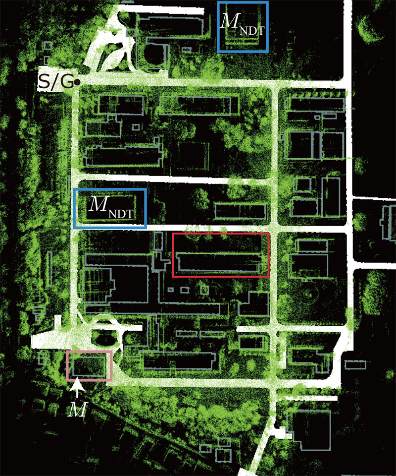
Point cloud map build by using online SLAM approach
- [1] H. Durrant-Whyte and T. Baliey, “Simultaneous Localization and Mapping: Part I,” IEEE Robotics and Automation Magazine, Vol.13, No.2, pp. 99-110, 2006.
- [2] T. Baliey and H. Durrant-Whyte, “Simultaneous Localization and Mapping (SLAM): Part II,” IEEE Robotics and Automation Magazine, Vol.13, No.3, pp. 108-117, 2006.
- [3] F. Moosmann and C. Stiller, “Velodyne SLAM,” Proc. of the IEEE Intelligent Vehicles Symp., pp. 393-398, 2011.
- [4] J. Zhang and S. Singh, “LOAM: Lidar Odometry and Mapping in Real-Time,” Proc. of the Robotics: Science and Systems, 2014.
- [5] T. Shan and B. Englot, “LeGO-LOAM: Lightweight and Ground-Optimized Lidar Odometry and Mapping on Variable Terrain,” Proc. of the IEEE/RSJ Int. Conf. on Intelligent Robots and Systems, pp. 4758-4765, 2018.
- [6] M. Hentschel, O. Wulf, and B. Wagner, “A GPS and Laser-Based Localization for Urban and Non-Urban Outdoor Environments,” Proc. of the IEEE/RSJ Int. Conf. on Intelligent Robots and Systems, pp. 149-154, 2008.
- [7] M. Hentschel and B. Wagner, “Autonomous Robot Navigation Based on OpenStreetMap Geodata,” Proc. of the IEEE Int. Conf. on Intelligent Transportation Systems, pp. 1645-1650, 2010.
- [8] K. Irie and M. Tomono, “Localization and Road Boundary Recognition in Urban Environments Using Digital Street Maps,” Proc. of the IEEE Int. Conf. on Robotics and Automation, pp. 4493-4499, 2012.
- [9] S. Hoshino and H. Yagi, “Mobile Robot Localization Using Map Based on Cadastral Data for Autonomous Navigation,” J. Robot. Mechatron., Vol.34, No.1, pp. 111-120, 2022.
- [10] D. Fox, W. Burgardy, F. Dellaert, and S. Thrun, “Monte Carlo Localization: Efficient Position Estimation for Mobile Robots,” Proc. of the 16th National Conf. on Artificial Intelligence, pp. 343-349, 1999.
- [11] S. Thrun, D. Fox, W. Burgard, and F. Dellaert, “Robust Monte Carlo Localization for Mobile Robots,” Artificial Intelligence, Vol.128, Nos.1-2, pp. 99-141, 2001.
- [12] E. Olson, J. Leonard, and S. Teller, “Fast Iterative Alignment of Pose Graphs with Poor Initial Estimates,” Proc. of the IEEE Int. Conf. on Robotics and Automation, pp. 2262-2269, 2006.
- [13] K. Konolige, G. Grisetti, R. Kümmerle, W. Burgard, B. Limketkai, and R. Vincent, “Efficient Sparse Pose Adjustment for 2D Mapping,” Proc. of the IEEE/RSJ Int. Conf. on Intelligent Robots and Systems, pp. 22-29, 2010.
- [14] R. Kümmerle, G. Grisetti, H. Strasdat, K. Konolige, and W. Burgard, “G2o: A General Framework for Graph Optimization,” Proc. of the IEEE Int. Conf. on Robotics and Automation, pp. 3607-3613, 2011.
- [15] P. Biber and W. Strasser, “The Normal Distributions Transform: A New Approach to Laser Scan Matching,” Proc. of the IEEE/RSJ Int. Conf. on Intelligent Robots and Systems, Vol.3, pp. 2743-2748, 2003.
- [16] M. Magnusson, A. Lilienthal, and T. Duckett, “Scan Registration for Autonomous Mining Vehicles Using 3D-NDT,” J. of Field Robotics, Vol.24, No.10, pp. 803-827, 2007.
- [17] E. Takeuchi and T. Tsubouchi, “A 3-D Scan Matching Using Improved 3-D Normal Distributions Transform for Mobile Robotic Mapping,” Proc. of the IEEE/RSJ Int. Conf. on Intelligent Robots and Systems, pp. 3068-3073, 2006.
- [18] N. Akai, L. Y. Morales, T. Yamaguchi, E. Takeuchi, Y. Yoshihara, H. Okuda, T. Suzuki, and Y. Ninomiya, “Autonomous Driving Based on Accurate Localization Using Multilayer LiDAR and Dead Reckoning,” Proc. of the IEEE Int. Conf. on Intelligent Transportation Systems, pp. 1-6, 2017.
This article is published under a Creative Commons Attribution-NoDerivatives 4.0 Internationa License.