
Abstract
Monitoring of Land use and Land cover (LULC) changes is a highly encumbering task for humans. Therefore, machine learning based classification systems can help to deal with this challenge. In this context, this study evaluates and compares the performance of two Single Learning (SL) techniques and one Ensemble Learning (EL) technique. All the empirical evaluations were over the open source LULC dataset proposed by the German Center for Artificial Intelligence (EuroSAT), and used the performance criteria -accuracy, precision, recall, F1 score and change in accuracy for the EL classifiers-. We firstly evaluate the performance of SL techniques: Building and optimizing a Convolutional Neural Network architecture, implementing Transfer learning, and training Machine learning algorithms on visual features extracted by Deep Feature Extractors. Second, we assess EL techniques and compare them with SL classifiers. Finally, we compare the capability of EL and hyperparameter tuning to improve the performance of the Deep Learning models we built. These experiments showed that Transfer learning is the SL technique that achieves the highest accuracy and that EL can indeed outperform the SL classifiers.
Access this chapter
Tax calculation will be finalised at checkout
Purchases are for personal use only
Notes
References
Alam, A., Bhat, M.S., Maheen, M.: Using Landsat satellite data for assessing the land use and land cover change in Kashmir valley. GeoJournal 85(6), 1529–1543 (2019). https://doi.org/10.1007/s10708-019-10037-x
Athiwaratkun, B., Kang, K.: Feature representation in convolutional neural networks CoRR abs/1507.02313 (2015). http://arxiv.org/abs/1507.02313
Aung, S.W.Y., Khaing, S.S., Aung, S.T.: Multi-label land cover indices classification of satellite images using deep learning. In: Zin, T.T., Lin, J.-W. (eds.) ICBDL 2018. AISC, vol. 744, pp. 94–103. Springer, Singapore (2019). https://doi.org/10.1007/978-981-13-0869-7_11
Bergstra, J., Bengio, Y.: Random search for hyper-parameter optimization. J. Mach. Learn. Res. 13, 281–305 (2012)
Bernasconi, E., Pugliese, F., Zardetto, D., Scannapieco, M.: Satellite-net: automatic extraction of land cover indicators from satellite imagery by deep learning (2019)
Chang, C.C., Lin, C.J.: LIBSVM: a library for support vector machines. ACM Trans. Intell. Syst. Technol. 2, 27:1–27:27 (2011). http://www.csie.ntu.edu.tw/cjlin/libsvm
Chollet, F.: Complete guide to transfer learning fine-tuning in keras (2020)
Ghimire, B., Rogan, J., Rodriguez-Galiano, V., Panday, P., Neeti, N.: An evaluation of bagging, boosting, and random forests for land-cover classification in cape cod, Massachusetts, USA. GIScience Remote Sens. 49, 623–643 (2012). https://doi.org/10.2747/1548-1603.49.5.623
Helber, P., Bischke, B., Dengel, A., Borth, D.: Eurosat: A novel dataset and deep learning benchmark for land use and land cover classification. IEEE J. Sel. Top. Appl. Earth Obs. Remote Sens. 12(7), 2217–2226 (2019)
Huang, G., Liu, Z., Weinberger, K.Q.: Densely connected Convolutional networks. CoRR abs/1608.06993 (2016). http://arxiv.org/abs/1608.06993
Hussain, M., Bird, J.J., Faria, D.R.: A study on cnn transfer learning for image classification. In: Lotfi, A., Bouchachia, H., Gegov, A., Langensiepen, C., McGinnity, M. (eds.) UKCI 2018. AISC, vol. 840, pp. 191–202. Springer, Cham (2019). https://doi.org/10.1007/978-3-319-97982-3_16
Jansen, L., Gregorio, A.: Land Cover Classification System (LCCS): Classification Concepts and User Manual (2000)
Jozdani, S.E., Johnson, B.A., Chen, D.: Comparing deep neural networks, ensemble classifiers, and support vector machine algorithms for object-based urban land use/land cover classification. Remote Sens. 11(14), 1713 (2019). https://doi.org/10.3390/rs11141713
Kalliatakis, G.: Keras VGG16 places365 github repository (2017). https://github.com/GKalliatakis/Keras-VGG16-places365
Krizhevsky, A., Sutskever, I., Hinton, G.: Imagenet classification with deep convolutional neural networks. Neural Inf. Process. Syst. 25 (2012). https://doi.org/10.1145/3065386
Lo, C.: Applied remote sensing. Geocarto Int. 1(4), 60 (1986). https://doi.org/10.1080/10106048609354071
Mohd Aszemi, N., Panneer Selvam, D.D.D.: Hyperparameter optimization in convolutional neural network using genetic algorithms. Int. J. Adv. Comput. Sci. Appl. 10, 269–278 (2019). https://doi.org/10.14569/IJACSA.2019.0100638
O’Malley, T., Bursztein, E., Long, J., Chollet, F., Jin, H., Invernizzi, L., et al.: Keras Tuner (2019). https://github.com/keras-team/keras-tuner
O’Shea, K., Nash, R.: An introduction to convolutional neural networks. CoRRabs/1511.08458 (2015). http://arxiv.org/abs/1511.08458
Pedregosa, F., et al.: Scikit-learn: machine learning in python. J. Mach. Learn. Res. 12, 2825–2830 (2011)
Ratajczak, R., Crispim-Junior, C.F., Faure, E., Fervers, B., Tougne, L.: Automatic land cover reconstruction from historical aerial images: an evaluation of features extraction and classification algorithms. IEEE Trans. Image Process. 28(7), 3357–3371 (2019)
Smith, G.: Remote sensing of land use and land cover: principles and applications, by C. P. Giri, Boca Raton. Int. J. Remote Sens. 35(6), 2392–2393 (2014). https://doi.org/10.1080/01431161.2014.891560
Sokal, R.R.: classification: purposes, principles, progress, prospects. Science 185(4157), 1115–1123 (1974). https://doi.org/10.1126/science.185.4157.1115
Szegedy, C., Vanhoucke, V., Ioffe, S., Shlens, J., Wojna, Z.: Rethinking the inception architecture for computer vision (2016). https://doi.org/10.1109/CVPR.2016.308
Talukdar, S., Singha, P., Mahato, S., Shahfahad, S.P., Liou, Y.-A., Rahman, A.: Land-use land-cover classification by machine learning classifiers for satellite observations—a review. Remote Sens. 12(7), 1135 (2020). https://doi.org/10.3390/rs12071135
Tong, X.Y., et al.: Land-cover classification with high-resolution remote sensing images using transferable deep models (2018)
Wolpert, D.H.: Stacked generalization. Neural Netw. 5(2), 241–259 (1992). https://doi.org/10.1016/S0893-6080(05)80023-1
Cheng, X., Namjoshi, N., Rodriguez, R.: Temporal analysis of regional sustainability using CNNs and satellite data (2018)
Yang, Y., Newsam, S.: Bag-of-visual-words and spatial extensions for land-use classification, GIS 2010, pp. 270–279. Association for Computing Machinery, New York (2010). https://doi.org/10.1145/1869790.1869829
Zhou, B., Lapedriza, A., Khosla, A., Oliva, A., Torralba, A.: Places: A 10 million image database for scene recognition. IEEE Trans. Pattern Anal. Mach. Intell. 40(6), 1452–1464 (2018). https://doi.org/10.1109/TPAMI.2017.2723009
Author information
Authors and Affiliations
Corresponding author
Editor information
Editors and Affiliations
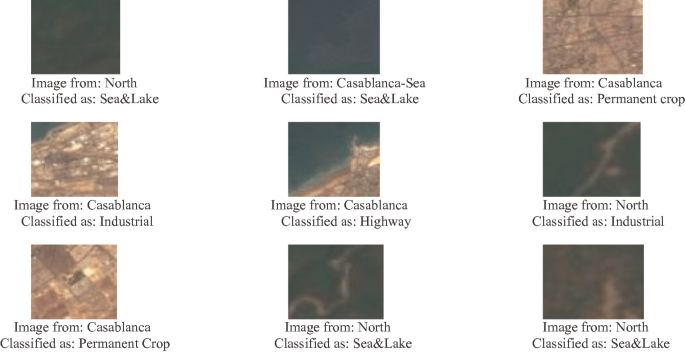
Appendix A - Comparison of the Performance of Our Models on Moroccan LULC Images
Appendix A - Comparison of the Performance of Our Models on Moroccan LULC Images
We aim to use the models we built during this work to construct a Moroccan LULC dataset. Indeed, we will choose one of these models to be used as an annotator of Moroccan satellite images. Therefore, we decided to test these classifiers’ ability to generalize to images of Moroccan regions. In this appendix we present the classification results of the four classifiers (i.e. LULC-Net, VGG16, VGG16 + LR and DLEnsemble1). The nine images we tested our models on are of the city of Casablanca where Industrial, Residential, Sea & Lake and highway classes are present, and of the North of Morocco where classes such as Forest, Pasture, River and Annual Corp are present.
-
LULC-Net

-
VGG16
-
VGG16 + LR

-
DLEnsemble1


Rights and permissions
Copyright information
© 2021 Springer Nature Switzerland AG
About this paper

Cite this paper
Benbriqa, H., Abnane, I., Idri, A., Tabiti, K. (2021). Deep and Ensemble Learning Based Land Use and Land Cover Classification. In: Gervasi, O., et al. Computational Science and Its Applications – ICCSA 2021. ICCSA 2021. Lecture Notes in Computer Science(), vol 12951. Springer, Cham. https://doi.org/10.1007/978-3-030-86970-0_41
Download citation
DOI: https://doi.org/10.1007/978-3-030-86970-0_41
Published:
Publisher Name: Springer, Cham
Print ISBN: 978-3-030-86969-4
Online ISBN: 978-3-030-86970-0
eBook Packages: Computer ScienceComputer Science (R0)