
Abstract
This chapter is divided into three parts. Sections 23.1–23.5 introduce the typical fields of application of marine geographic information systems. It begins with the application and the conflicts of using the sea for, e.g., energy production and transport, versus environmental protection. Furthermore, the methodology of GIS-based analyses in the marine context and the special conditions of research and work in this field are considered, including aspects of data, data acquisition, data modeling, data banking, standardization, and harmonization. Then, this part continues with specific applications such as the maritime spatial planning process and integrated coastal zone management (ICZM), plus examples in the field of emergency response to pollution. One power user of marine GIS techniques is commercial shipping. Sections 23.6–23.9 describe the nautical and hydrographic aspects of the topic. The subject of Sect. 23.10 is the conjunction between geostatistics and geographical information systems in the GIS-based ecoregionalization of the North Sea and the Baltic Sea to constitute a new information layer with the help of spatial interpolation as the basis for a maritime spatial planning process.
Access this chapter
Tax calculation will be finalised at checkout
Purchases are for personal use only
Abbreviations
- AIS:
-
Automatic Identification System
- ARPA:
-
Automatic Radar Plotting Aids
- AUV:
-
Autonomous Underwater Vehicle
- AWI:
-
Alfred-Wegener-Institute
- ArcIMS:
-
ArcGIS Internet Map Server
- BSH:
-
Bundesamt für Seeschifffahrt und Hydrographie, Federal Maritime and Hydrographic Agency
- CART:
-
Classification and Regression Tree
- CHAID:
-
Chisquare Interaction Detection Method
- CTD:
-
conductivity, temperature, and density
- DBMS:
-
database management system
- DGPS:
-
Differential Global Positioning System
- DSV:
-
Deep Submergence Vehicle
- EBL:
-
Electronic Bearing Line
- ECDIS:
-
Electronic Chart Display and Information System
- EDMED:
-
European Directory of Marine Environmental Datasets
- EEZ:
-
Exclusive Economic Zone
- EMODNET:
-
European Marine Observation and Data Network
- EMSA:
-
European Maritime Safety Agency
- ENC:
-
Electronic Navigational Chart
- ENVISAT:
-
Environmental Satellite
- ER:
-
Engineering Report
- ER:
-
entity relationship
- EROCIPS:
-
Emergency Response to coastal Oil, Chemical and Inert Pollution from shipping
- EUNIS:
-
European Nature Information System
- Esri:
-
Environmental Systems Research Institute
- FFH:
-
Fauna Flora Habitat
- FGDC:
-
US Federal Geographic Data Committee
- GIS:
-
Geographic Information System
- GPS:
-
Global Positioning System
- GSM:
-
Global System for Mobile communication
- HDOP:
-
horizontal dilution of precision
- HMI:
-
human–machine interface
- ICES:
-
International Council for the Exploration of the Sea
- ICZM:
-
Integrated Coastal Zone Management
- IHO:
-
International Hydrographic Organization
- IMO:
-
International Maritime Organization
- IMS:
-
Internet Map Server
- INS:
-
Integrated Navigation System
- INSPIRE:
-
Infrastructure for Spatial Information in the European Community
- ISO:
-
International Organization for Standardization
- IfM:
-
Institute of Marine Research
- LIDAR:
-
light detection and ranging, Laser Scanning
- MDM:
-
Marine Data Model
- ME:
-
mean error
- MPE:
-
median percentile error
- MS:
-
multispectral
- MSC:
-
Maritime Safety Committee
- MSDI:
-
Marine Spatial Data Infrastructure
- MSP:
-
Maritime Spatial Planning
- MSSQL:
-
Microsoft SQL
- MUDAB:
-
Marine Environmental Data Base
- NATO:
-
North Atlantic Treaty Organization
- NGO:
-
non-governmental organization
- NM:
-
nautical miles
- NOAA:
-
US National Oceanic and Atmospheric Administration
- PC:
-
Personal Computer
- PIANC:
-
Permanent International Association of Navigation Congresses
- QDA:
-
Quadratic Discriminant Analysis
- QUEST:
-
Quick, Unbiased, Efficient, Statistical Tree
- RENC:
-
Regional Electronic Chart Coordinating Centre
- ROV:
-
Remotely Operated Vehicle
- SOTDMA:
-
Self-Organizing Time Division Multiple Access
- SQL:
-
Structured Query Language
- TIN:
-
Triangulated Irregular Network
- TSS:
-
Traffic separation scheme
- UBA:
-
Umweltbundesamt (German Federal Environmental Agency)
- UN:
-
United Nations
- URL:
-
Uniform Resource Locator
- USACE:
-
US Army Corps of Engineers
- UTM:
-
Universal Transversal Mercator
- VHF:
-
Very-high-frequency
- VPS:
-
Vorsorgeplanungssystem
- VRM:
-
Variable Range Marker
- WEND:
-
World-wide Electronic Navigational Chart Data Base
- WFD:
-
Water Framework Directive
- WMO:
-
World Meteorological Organization
- WOCE:
-
World Ocean Circulation Experiment
- XML:
-
Extensible Markup Language
References
Bundesamt für Seeschifffahrt und Hydrographie: CONTIS maps (BSH, Hamburg, Rostock 2011) available from http://www.bsh.de/en/Marine_uses/Industry/CONTIS_maps/index.jsp (last accessed 9 February 2010)
Commission of the European Communities: Building a European Marine Knowledge Infrastructure: Roadmap for a European Marine Observation and Data Network (EC, Brussels 2009)
M. Schlüter, W. Schröder, L. Vetter, K. Jerosch, R. Pesch, A. Köberle, C. Morchner, U. Fritsche: Marine geo-information-system for spatial analysis and visualization of heterogeneous data (MarGIS), Geotechnol. Sci. Rep. 8, 88–101 (2006)
D. Wright, M. Blongewicz, P. Halpin, J. Breman: Arc Marine – GIS for a Blue Planet (ESRI, Redlands 2007)
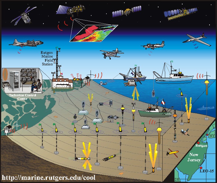
Rutgers University Coastal Ocean Observation Lab (Rutgers Univ., Newark 2011), available from http://dusk.geo.orst.edu/djl/arcgis//images/rutgers_cool.jpg (last accessed 9 February 2010)
International Hydrographic Organization: http://www.iho.int/english/home/ (last accessed 9 February 2010)
L. Vetter, A. Koeberle: Web-based marine geoinformation services in MarGIS, Geotechnol. Sci. Rep. 4, 88–90 (2004)
W. Kresse, K. Fadaie: ISO Standards for Geographic Information (Springer, Berlin, Heidelberg 2004)
M. Schlüter, W. Schröder, L. Vetter: Marine geo-information-system for visualisation and typology of marine data, Geotechnol. Sci. Rep. 2, 17–22 (2003)
Bundesamt für Seeschifffahrt und Hydrographie, Spatial Planning in the German EEZ (BSH, Hamburg, Rostock 2010), available from http://www.bsh.de/en/Marine_uses/Spatial_Planning_in_the_German_EEZ/index.jsp (last accessed 9 February 2010)
Commission of the European Communities: Progress Report on the EUʼs Integrated Maritime Policy (EC, Brussels 2009)
European Commission: Legal Aspects of Maritime Spatial Planning Framework Service Contract, No. FISH/2006/09 – LOT2 (EC, Brussels 2008)
D.J. Barlett: Working on the frontiers of science: Applying GIS to the coastal zone. In: Marine and Coastal Geographical Information Systems, ed. by D.J. Wright, D.J. Bartlett (Taylor Francis, London 2000) pp. 11–14
http://www.ikzm-oder.de/en/ (last accessed 9 February 2010)
http://www.vps-web.de/ (last accessed 9 February 2010)
http://cleanseanet.emsa.europa.eu/ (last accessed 9 February 2010)
http://www.erocips.org/intro.htm (last accessed 9 February 2010)
InterRisk project: http://interrisk.nersc.no/ (last accessed 9 February 2010)
IMO: Performance Standards for ECDIS, 1995 edn. (Resolution A.817(19)) and current edition (Resolution MSC.232(82)) (International Maritime Organization, London 2006)
G. Hempel, K. Sherman (Eds.): Large Marine Ecosystems of the World: Trends in Exploitation, Protection, and Research (Elsevier, Amsterdam 2003)
UNEP (United Nations Environment Programme): Marine and coastal ecosystems and human well-being: A synthesis report based on the findings of the Millennium Ecosystem Assessment (Nairobi 2006)
R.G. Bailey: Ecoregion-Based Design for Sustainability (Springer, New York 2002) p. 240
R.G. Bailey: Identifying ecoregion boundaries, J. Environ. Manag. 34, 14–26 (2005)
W. Schröder, G. Schmidt: Defining ecoregions as framework for the assessment of ecological monitoring networks in Germany by means of GIS and classification and regression trees (CART), Gate Environ. Health Sci. 3, 1–9 (2001)
A.L. Gallant, T.R. Loveland, T. Sohl, D. Napton: Using an ecoregion framework to analyze land-cover and land-use dynamics, J. Environ. Manag. 34, 89–110 (2004)
T.R. Loveland, J.M. Merchant: Ecoregions and ecoregionalisation: Geographical and ecological perspectives, Environ. Manag. 34, 1–13 (2004)
R. Pesch, K. Jerosch, M. Schlüter, W. Schröder: Using decision trees to predict benthic communities within and near the German Exclusive Economic Zone (EEZ) of the North Sea, Environ. Monit. Assess. 136, 313–325 (2008)
W. Schröder, R. Pesch: Synthesizing bioaccumulation data from the German metals in mosses surveys and relating them to ecoregions, Sci. Total Environ. 374, 1–17 (2006)
W. Schröder, R. Pesch, G. Schmidt: Statistical classification of terrestrial and marine ecosystems for environmental planning, Landsc. Online 2, 1–22 (2007)
M. Hill, J. Briggs, P. Minto, D. Bagnall, K. Foley, A. Williams: Guide to Best Practice in Seascape Assessment (Bangor, Dublin 2001)
M.D. Spalding, H.E. Fox, G.R. Allen, N. Davidson, Z.A. Ferdaña, M. Finlayson, B.S. Halpern, M.A. Jorge, A. Lombana, S.A. Lourie, K.D. Martin, E. Mcmanus, J. Molnar, C.A. Recchia, J. Robertson: Marine ecoregions of the world: A bioregionalization of coastal and shelf areas, BioScience 57, 573–583 (2007)
M.K. Wali: ecoVocabulary: A glossary of our times, Bull. Ecol. Soc. Am. 76, 106–111 (1995)
W. Schröder: Naturräumliche Gliederung Deutschlands. Methoden, Ziele und Anwendungsmöglichkeiten der potenziell natürlichen Vegetation, Der "Gute ökologische Zustand" naturnaher terrestrischer Ökosysteme – ein Indikator der Biodiversität? Tagungsband zum Workshop in Dessau (Umweltbundesamt, Dessau 2008) pp. 51–71
R.G. Bailey: Ecoregions: The Ecosystem Geography of the Oceans and the Continents (Springer, New York 1998) p. 192
ICES Marine Habitat Committee: Report of the Working Group on Habitat Mapping (WGMHM) (International Council for the Exploration of the Sea, Bremerhaven, Kopenhagen 2005)
M. Busch, R. Pesch, M. Schlüter, W. Schröder: GIS-Kartierung von Meeresbodenhabitaten gemäß European Nature Information System – EUNIS. In: Angewandte Geoinformatik, ed. by J. Strobel, T.H. Blaschke, G. Griesebner (Wichmann, Heidelberg 2009) pp. 442–451
W. Schröder, R. Pesch, H. Pehlke, M. Busch: MarGIS. Marines Geo-Informationssystem zur Visualisierung und Typologisierung meeres-geowissenschaftlicher Daten. Teilprojekt: Flächenhafte Typologisierung des Meeresgrunds mit Hilfe geostatistischer und multivariat-statistischer Verfahren, Final report BMBF/DFG FKZ 03F0370 (2005)
R. Pesch, G. Schmidt, W. Schröder, I. Weustermann: Application of CART in ecological landscape mapping: Two case studies, Ecol. Indic. 11, 115–122 (2009)
E. Rachor, P. Nehmer: Erfassung und Bewertung ökologisch wertvoller Lebensräume in der Nordsee. Abschlußbericht für das FuE-Vorhaben FKZ 899 85 310 (Bundesamt für Naturschutz) (Alfred-Wegener-Institut, Bremerhaven 2003)
D.G. Krige: A statistical approach to some basic mine evaluation problems on the witwatersrand, J. Chem. Metall. Min. Soc. S. Afr. 52, 119–139 (1951)
G. Matheron: Les variables régionalisées et leur estimation. Ph.D. Thesis (Masson, Paris 1965)
G. Matheron: The theory of regionalized variables and its application. Ph.D. Thesis (Ecole National Superieure des Mines, Fontainebleau 1971)
O. Fränzle, W. Killisch: Aufschlüsselung des Informationsgehaltes umweltrelevanter, flächenbezogener Strukturdaten, Umweltforschungsplan des Bundesministers des Innern – Ökologie-Forschungsbericht 101 04 035 (The Federal Ministry of the Interior, Berlin 1980) pp. VII + 436
H. Chihi, A. Galli, C. Ravenne, M. Tesson, G. De Marsily: Estimating the depth of stratigraphic units from marine seismic profiles using nonstationary geostatistics, Nat. Resour. Res. 9, 77–95 (2000)
P. Petitgas: Sole egg distribution in space and time characterized by a geostatistical model and its estimation variance, ICES J. Mar. Sci. 54(2), 213–225 (1997)
K.F. Poon, R.W.H. Wong, M.H.W. Lam, H.Y. Yeung, T.K.T. Chiu: Geostatistical modelling of the spatial distribution of sewage pollution in coastal sediments, Water Res. 34(1), 99–108 (2000)
V. Stelzenmüller: Möglichkeiten und Grenzen geostatistischer Verfahren in den Fischereiwissenschaften. Analyse räumlicher und zeitlicher Variabilität von Fischpopulationen. Doctoral Thesis (Carl von Ossietzky Universität, Oldenburg 2005)
K. Johnston, V.M. Ver Hoef, K. Krivoruchko, N. Lucas: Using ArcGIS Geostatistical Analyst (ESRI, Tulsa 2001)
J. Lawrence, S. Southworth, D.M. Sutphin, G.A. Rubis, J.H. Schuenemeyer, W.C. Burton: Validation of the relation between structural patterns in fractured bedrock and structural information interpreted from 2-D-variogram maps of water-well yields in Loudoun county, Virginia, Nat. Resour. Res. 13(4), 255–264 (2004)
C.A. Cambardella, T.B. Moorman, J.M. Novak, T.B. Parkin, D.L. Karlen, R.F. Turco, A.E. Konopka: Field-scale variability of soil properties in central Iowa soils, Soil Sci. Soc. Am. J. 58, 1501–1511 (1994)
R. Webster, M. Oliver: Geostatistics for Environmental Scientists (Wiley, Chichester, 2000)
G.C.A. Duineveld, A. Künitzer, U. Niermann, P.A.W.J. De Wilde, J.S. Gray: The macrobenthos of the North Sea, Neth. J. Sea. Res. 28, 53–65 (1991)
C. Heip, J.A. Craeymeersch: Benthic community structures in the North Sea, Helgoland Mar. Res. 49, 313–328 (1995)
N.S. Jones: Marine bottom communities, Biol. Rev. 25, 283–313 (1950)
A. Künitzer, D. Basford, J.A. Craeymeersch, J.M. Dewarumez, J. Dörjes, G.C.A. Duineveld, A. Eleftheriou, C. Heip, P. Herman: The benthic infauna of the North Sea: Species distribution and assemblages, ICES J. Mar. Sci. 49, 127–143 (1992)
C.G.J. Peterson: Valuation of the sea II. The animal communities on the sea-bottom and their importance for marine zoogeography, Rep. Dan. Biol. Stn. 21, 1–44 (1914)
A. Remane: Einführung in die zoologische Ökologie der Nord- und Ostsee. In: Tierwelt der Nord- und Ostsee Ia, ed. by G. Grimpe, E. Wagner (Akad. Verlagsges., Leipzig 1940)
H. Salzwedel, E. Rachor, D. Gerdes: Benthic macrofauna communities in the German Bight, Veröff. Inst. Meeresforsch. Bremerhav. 20, 199–267 (1985)
G.E. Thorson: Bottom communities (sublittoral or shallow shelf), Geol. Soc. Am. Mem. 67, 461–534 (1957)
M. Glémarec: The benthic communities of the European North Atlantic shelf, Oceanogr. Mar. Biol. 11, 263–289 (1973)
S. Jennings, J. Lancaster, A. Woolmer, J. Cotter: Distribution, diversity and abundance of epibenthic fauna in the North Sea, J. Mar. Biol. Assoc. UK 79, 385–399 (2001)
R. Callaway, J. Alsvåg, I. De Boois, J. Cotter, A. Ford, H. Hinz, S. Jennings, I. Kröncke, J. Lancaster, G. Piet, P. Prince, S. Ehrich: Diversity and community structure of epibenthic invertebrates and fish in the North Sea, ICES J. Mar. Sci. 59, 1199–1214 (2002)
P.A.R. Hockey, G.M. Branch: Conserving marine biodiversity on the African coast: Implications of a terrestrial perspective, Biol. Conserv. 76, 216–217 (1996)
R.M. Hughes: Use of ecoregions in biological monitoring. In: Biological Monitoring of Aquatic Systems, ed. by S.L. Loeb, A. Spacie (CRC, Boca Raton 1997) pp. 125–151
S.A. Lourie, A.C.J. Vincent: Using biogeography to help set priorities in marine conservation, Conserv. Biol. 18, 1004–1020 (2004)
C. Reiniger: Bioregional planning and ecosystem protection. In: Ecological Design and Planning, ed. by G.F. Thompson, F. Steiner (Wiley, New York 1997) pp. 185–200
H. Reiss, I. Kröncke: Seasonal variability of infaunal community structures in three areas of the North Sea under different environmental conditions, Estuar. Coast Shelf Sci. 65, 253–274 (2005)
R.K. Johnson, W. Goedkoop: Littoral macroinvertebrate communities: Spatial scale and ecological relationships, Freshw. Biol. 47, 1840–1854 (2002)
G.A. Krubnick, J.W. Kress: Hotspots and ecoregions: A test of conservation priorities using taxonomic data, Biodivers. Conserv. 12(11), 2237–2253 (2003)
C. Parmesan, S. Gaines, L. Gonzalez, D.M. Kaufman, J. Kingsolver, A.T. Peterson, R. Sagarin: Empirical perspectives on species borders: From traditional biogeography to global change, Oikos 108, 58–75 (2005)
M. Rossbach, G. Kniewald: Concepts of marine specimen banking, Chemosphere 34(9), 1997–2010 (1997)
B.B. Bernstein, S.B. Weisberg: Southern Californiaʼs marine monitoring system ten years after the National Research Council evaluation, Environ. Monit. Assess. 81(1–3), 3–14 (2003)
C.N. Bianchi, C. Morri: Marine biodiversity of the Mediterranean Sea: Situation, problems and prospects for future research, Mar. Pollut. Bull. 40, 367–376 (2000)
A. Danielsson, L. Rahm, D.J. Conley, J. Carstensen: Identification of characteristic regions and representative stations. A study of water quality variables in the Kattegat, Environ. Monit. Assess. 90, 203–224 (2004)
O. Moog, A. Schmidt-Kloiber, T. Ofenbock, J. Gerritsen: Does the ecoregion approach support the typological demands of the EU Water Framework Directive?, Hydrobiologia 516, 21–33 (2004)
Author information
Authors and Affiliations
Corresponding authors
Editor information
Editors and Affiliations
Rights and permissions
Copyright information
© 2011 Springer-Verlag
About this chapter
Cite this chapter
Vetter, L., Jonas, M., Schröder, W., Pesch, R. (2011). Marine Geographic Information Systems. In: Kresse, W., Danko, D. (eds) Springer Handbook of Geographic Information. Springer Handbooks. Springer, Berlin, Heidelberg. https://doi.org/10.1007/978-3-540-72680-7_23
Download citation
DOI: https://doi.org/10.1007/978-3-540-72680-7_23
Publisher Name: Springer, Berlin, Heidelberg
Print ISBN: 978-3-540-72678-4
Online ISBN: 978-3-540-72680-7
eBook Packages: Earth and Environmental ScienceEarth and Environmental Science (R0)